|

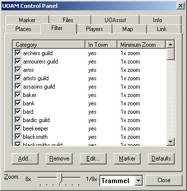
The filter pane is where you manage all the categories recognized by UOAM.
By placing a checkmark in the box next to a category on this list, you cause
UOAM to display all the labels associated with that category in the places pane
and (assuming that the labels aren't disabled in the map pane and the map is
being displayed at the proper zoom level) on the map.
Clicking on a column will sort the list on the contents of that column.
The columns are:
Category - the type of place
In Town - a "yes" in this column indicates that labels assigned to
this category are considered "shops" or "town objects". "Town objects"
can be displayed on the map by name or by category. Objects that are not
"town objects" are always displayed by name.
Minimum Zoom - the lowest zoom level at which labels assigned to
this category will be displayed. As you zoom out beyond this zoom level,
labels assigned to this category will not appear on the map even if there
is a check in the checkbox (although they will still appear in the places
pane). You can change this setting by using the pop-up menu as described
below.
The buttons allow you to manage the categories in this list.
The buttons are:
Add - adds a category this list. This button brings up a dialog
that allows you to create a category, give it a name, indicate whether it
represents a "town object" or not, and set its icon, font and color.
This dialog also contains a preview of what a label will look like if it
is assigned to this category. (NOTE: Category names may not contain the
colon ":" character. Colons are automatically removed from category names
when they are created.)
Remove - removes all selected categories from the list, along with any
places that might have been assigned to them.
Edit - allows you to modify a category's settings.
Marker - drops a marker on the nearest marked location that belongs
to the selected category.
Defaults - resets all categories to their default color and font.
(This button does not affect icon settings.)
Also you can right-click on the list to see a pop-up menu that provides
additional commands. In addition to the commands listed above, you can
use the pop-up menu to change the "in town" state and the minimum zoom
level of the selected categories. You can also show or hide groups of
categories this way.
Also on the pop-up menu are the following two commands: Center on
Nearest and Drop Marker on Nearest. These commands find the
nearest label in the selected set of categories and either center the map
or drop the marker on it. This is particularly handy for quickly locating
that certain type of shop.
At the bottom of this and every control pane is a zoom slider
which adjusts the zoom level of the map and a world slider that
tells UOAM whether it should display locations pertaining to Felucca or
Trammel. | 